Lithium Project - Mali
About Mali
Mali, officially the Republic of Mali, is a landlocked country in West Africa, a region geologically identified with the West African craton.
- Mali is the eighth largest country in Africa, with an area of just over 1,240,000 square kilometers.
- The population of Mali is 18 million.
- Its capital is Bamako.
- Mali consists of eight regions and its borders on the north reach deep into the middle of the Sahara Desert, while the country's southern part, where the majority of inhabitants live, features the Niger and Senegal rivers.
- The country's economy centers on agriculture and fishing.
- Some of Mali's prominent natural resources include gold; being the third largest producer of gold in the African continent; and salt.
Mali has embarked on economic liberalism since late 1980s
- Mali has a strong mining culture and a strong track record of according fast approvals of mining projects.
- Mali is the 3rd largest gold exporter in Africa.
- Mali is a politically stable country with excellent infrastructure, extremely friendly and hospitable people, good governance and very low level of corruption.
- The Attractive investment code from the Agency for the Promotion of Investments in Mali (API) has been attracting large private capital, whether foreign or domestic by which, the private sector now appears as the “engine” of economic growth.
Lithium Project - Mali
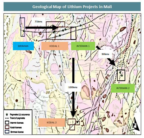
Intermin has acquired two world class Lithium mineral bearing permits in Faraba and Gouna with a combined area of 175 Sq Kms which comes in the Sikasso Region, about 200kms South-East of Mali Capitol ~ Bamako. They are well connected by National Highways RN7 & A5.
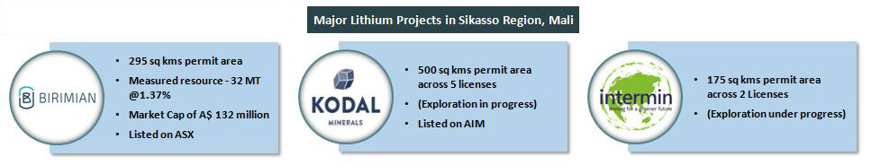
The neighbouring projects like Birimium – Goulamina Lithium Project reported JORC mineral resource of 32.9MT at 1.37%Li2O equivalent to 451,000 tonnes Li2O at 0.4% cutoff being listed on ASX and Kodal Minerals has 500 Sq Kms permit area across 5 licences are listed in the AIM (London Metal Exchange)
About the prospects
Faraba prospect is named after the village “FARABA” where the Intermin Prospect is located, near Toula village on RN7, which is 10 kilometers from Bougouni town; the prospect has good accessibility to the National Highway RN7 which is connecting Sikaso town with capital city of Bamako. Intermin prospect is within a short distance of 1.5 kilometers from the National Highway RN7. River ‘Baoule’ is running on the NW corner of the prospect at a distance of 800mts, which will be crucial for ore beneficiation.
Gouna Prospect is located in the southern region of Mali belonging to Sikasso region. Blakala and Gouna blocks are part of GOUNA Permit , both prospects can be accessible through all weather bitumen roads through Bougouni town (RN7)
The area is dominantly covered by granite. The granite is grey, coarse grained, non-foliated and contains quartz, feldspar, biotite, opaques and epidote. Dark green, coarse grained, grano-diorite occur as massive bodies and also as dike within in pegmatite. Aplites and pegmatites are also seen in the area. Intensive soil and lateritization is developed. Granites and Pegmatites are also lateritized.
History around the Prospect area
Russians have carried out extensive exploration activities in Bouguoni sector ( Sinsinkourou, Kola and Gouanala) in 1960’s. The SONAREM reports indicate that the pegmatite of Bougouni zone (Ngoulamina, NGouanala, Sogola, Sinsinkourou) are assayed to contain lithium within Spodumene. The values are comprised between 1 to 2.2% Li2O.
In the prospect areas, the pegmatite occurs in the form of veins, which are parallel and sub parallelin nature with few centimeter to 7 meters in width. The pegmatites contain quartz, Microcline Feldspar, albite, Muscovita Mica, smoky quartz, spodumene and opaques. The Sinsinkourou pegmatite field near Boughini stretches over 2 kms and are extending to a depth 200 mts as per the sonarem reports.
Intermin has developed a rapid and accelerated exploration aiming at advancing the project into exploitation in the short timeframe.
A total of 31 pits (1mx1mx1m) were dug in the area where pegmatites are exposed on 50m x 50m interval as area is mostly soil covered. Some of the pits exposed pegmatites at depth. During pitting / mapping some more pegmatites were located.
Trenching in the area was carried out to establish the width of the ore body and its interrelationship with other parallel pegmatites. A total of eight (8) trenches were made perpendicular to the strike of the pegmatites with a cumulative length of 106.40m
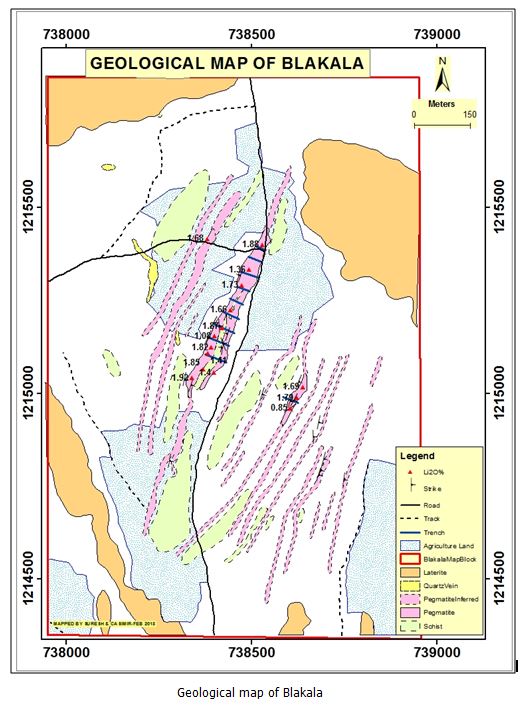
Blakala Block
Blakala block consists of pegmatite with spodumene, schistose rocks, quartz vein and laterite as the main litholgical units. Schist is found to be the oldest litho units encountered in the Blakala block, followed by pegmatite. Quartz vein might be a later intrusion. Lateralization is prominent and found on the Northwest, North east and South west corners of the Blakala block; small laterite horizon is also found on the south eastern region of the block. Schists are of quartz mica schist variety predominantly comprised of mica and quartz minerals with exceptional occurrences of actinolite, which indicate the greens schist facies of metamorphism. Schist is grayish in color in most cases and shows brownish color due to weathering.
Sample Results
Analytical Data of Samples Point To High Lithium Potential
- Grab samples were collected from the surface of all the pegmatites exposed analyzed at Shiva Laboratories, India
- The average Li2O across all samples collected and assayed is 1.63%
Future proposed work plan on permit
- Petrological studies and multi element analysis of Pegmatite ore body to understand the association of other mineral assemblages and gangue minerals.
- Trenching Operation: It is planned to undertake detailed trenching operation over the entire strike length of the pegmatite ore body to establish precise width and occurrences of additional parallel pegmatite ore bodies.
- Exploratory drilling: It is planned to undertake exploratory drilling by diamond drilling method to intersect the pegmatite ore body at 50mts, 100mts and 200mts depth.
- Resource Estimation: Based on the exploratory drilling data, ore body modelling will be carried and followed by Resource Estimation.
- Beneficiation Studies: A representative bulk sample of the spodumene bearing pegmatite ore sample will be submitted to reputed laboratory to carry out benefication studies, which is essential to understand the Process flow sheet, recoveries etc.,
- Feasibility studies
- Pilot Plant studies